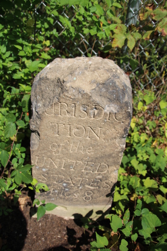
1650 Kenilworth Avenue NE; Washington, DC
The stone is along a fence, 500 feet northwest of the intersection of Eastern
Avenue NE and Kenilworth Avenue NE. Until 2013, there were three
trails that led to the stone. Because the area is now under development,
these trails may not be as easy to follow as they once were.
1) From the intersection of Eastern and Kenilworth,
follow the trail that begins at a separation in the fence along the
north side of Kenilworth. The trail
immediately winds to the right where it follows another fence
northwest along the edge of a gravel distribution lot. The trail forks when
the gravel lot fence begins to turn to the right; turn left here. The
left fork roughly parallels another fence and leads to the charred
rubble of a former dwelling. The stone is along the fence to the
right, about 50 feet before you reach the remains of the dwelling.
View route.
2) From the intersection of Eastern and Kenilworth, head southwest on Kenilworth
and turn right on Quarles Road.
Turn right again, before reaching 45th Street, onto a road leading
to a smokestack across the street from an apartment complex. As Kanon
explained in
Stoned Out of My Mind: A Guide to and Personal Reflections
of the Boundary Stones for the District of Columbia, "Just E of parking lot, look
for a hole in the black fence.
Follow a trail for about 300 ft. to another fence. Near a pool of water."
3) From the intersection of Eastern and Kenilworth, head southwest on
Kenilworth and turn right on Quarles Road. Turn right again when
Quarles Road ends at Anacostia Avenue. Anacostia ends shortly thereafter
at a forest, where a trail leads past the former dwelling to the
stone.
Zoom to street map.